Randonnée Marche Hergiswil (NW) - YHH065 Frakmüntegg - Alpnachstadt - Photo

YHH065 Frakmüntegg - Alpnachstadt

 yveshumbert
yveshumbert

Utilisateur

© OpenStreetMap contributors
Longueur
Longueur
7,9 km
Altitude max
Altitude max
1407 m
Dénivelé positif
Dénivelé positif
189 m
Km-Effort
Km-Effort  
13,6 km
Altitude min
Altitude min
441 m
Dénivelé négatif
Dénivelé négatif
1143 m
Boucle
Boucle
Non
Date de création :
2015-06-02 00:00:00.0
Dernière modification :
2015-06-02 00:00:00.0

(0 Avis)

Marche
Marche
3h00
Difficulté : Inconnu

Scannez ce code QR pour ouvrir la randonnée dans l'application SityTrail

Application GPS de randonnée GRATUITE

Logo SityTrail SityTrail

IGN / Instituts géographiques

Télécharger SityTrail sur l'App Store Télécharger SityTrail sur Google Play

Logo SityTrail SityTrail World

Le monde est à vous

Télécharger SityTrail sur l'App Store Télécharger SityTrail sur Google Play Télécharger SityTrail sur Huawei AppGallery

À propos

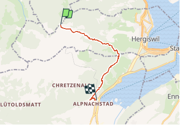
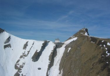
Randonnée Marche de 7,9 km à découvrir à Nidwald, Inconnu, Hergiswil (NW). Cette randonnée est proposée par yveshumbert.

Description

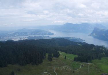
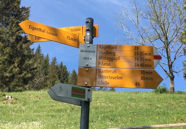
De Lucerne on prend le bus jusqu'à Kriens. De là on prend le télécabine jusqu'à Frakmüntegg. L'itinéraire facile se fait pratiquement tout en descente. A Alpnachstadt, on peut prendre le train pour rentrer à Lucerne

Profil altimétrique

Localisation

Pays :
Suisse
Région :
Nidwald
Département/Province :
Inconnu
Commune :
Hergiswil (NW)
Localité :
Unknown
Départ:(Dec)
Départ:(UTM)
443125 ; 5204399 (32T) N.

Randonnées à proximité

Randonnée A pied Kriens - Kriens Pilatus-Bahnen - Fräkmüntegg - Photo
A pied
PRO

A pied

Facile
Kriens, Lucerne, Inconnu, Suisse
6,4 km | 15,8 km-effort
3h 35min
Non
Randonnée A pied Schwarzenberg - Sonnhalde - Linden - Meiestoss - Moos - Photo
A pied
PRO

A pied

Facile
Schwarzenberg, Lucerne, Inconnu, Suisse
3,7 km | 4,4 km-effort
59min
Non
Randonnée A pied Kriens - Holderchäppeli - Ränggloch - Photo
A pied
PRO

A pied

Facile
Kriens, Lucerne, Inconnu, Suisse
3,9 km | 5,4 km-effort
1h 13min
Non
Randonnée A pied Schwarzenberg - Chraigütsch - Ober Lauelen - Photo
A pied
PRO

A pied

Facile
Schwarzenberg, Lucerne, Inconnu, Suisse
3,4 km | 6,8 km-effort
1h 32min
Non
Randonnée A pied Kriens - Rund um Kriens - Photo
A pied
PRO

A pied

Facile
Kriens, Lucerne, Inconnu, Suisse
3,8 km | 5,6 km-effort
1h 16min
Non
Randonnée Marche Kriens - eigenthal - Photo
Marche
JorgV

Marche

Très facile
Kriens, Lucerne, Inconnu, Suisse
3,4 km | 6,3 km-effort
1h 3min
Non
Randonnée A pied Schwarzenberg - Wassermoos - Lifelen - Photo
A pied
PRO

A pied

Facile
Schwarzenberg, Lucerne, Inconnu, Suisse
3,7 km | 5,2 km-effort
1h 11min
Non
Randonnée A pied Schwarzenberg - Lifelen - Moos - 850 - Meiestoss - Photo
A pied
PRO

A pied

Facile
Schwarzenberg, Lucerne, Inconnu, Suisse
3,3 km | 5,5 km-effort
1h 14min
Non
Randonnée A pied Schwarzenberg - Stafel - Trochenmattsattel - Stäfeli - Photo
A pied
PRO

A pied

Facile
Schwarzenberg, Lucerne, Inconnu, Suisse
3,2 km | 5,1 km-effort
1h 9min
Non


Fermer
Mes abonnements